 Map of the Lower Stanley Loop between Boise and Sunbeam. (1) Boise (2) Beacon Light Chevron in Eagle (3) Garden Valley Chevron (4) Sunbeam (5) Lower Stanley (6) Sawtooth Overlook (7) Idaho City (8) Boise. ~290 miles.
 Salmon River Scenic Byway just north of Lower Stanley on ID-75. The Walker Fire obscured the skyline that day.
 Salmon River Scenic Byway with close-ups of rides belonging to Grumbler, Kurt, Jack, and Bruce on ID-75 by the Salmon River.
 Salmon River Scenic Byway with Jack of Mesa, AZ on his black 1500 Drifter.
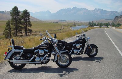
 Salmon River Scenic Byway with Grumbler's 1500 Classic and Jack's 1500 Drifter.
 Lower Stanley with view of the patio area from the Bridge Street Grill overlooking the Salmon River.
 Lower Stanley is where this rustic 2-story vacation home is located next to Bridge Street Grill by the Salmon River.
 Lower Stanley with the Salmon River looking north from patio of the Bridge Street Grill.
 Lower Stanley where the Walker Road fire was observed 20 miles southeast from patio of the Bridge Street Grill.
 Lower Stanley has this steel bridge spanning the Salmon River behind the Bridge Street Gill.
 Lower Stanley with the Salmon River and Sawtooth Range to the south from Bridge Street Grill.
 Lower Stanley with closer look of Salmon River and Sawtooth Range.
 Sawtooth Range Overlook features Kurt's 1500LC, Jack's 1500 Drifter, and Grumbler's 1500 Classic parked out front.
 Sawtooth Range Overlook with Kurt, Jack, and Grumbler in group pic taken by Bruce.
 Sawtooth Range Overlook with wooden sign in foreground.
 Gregory Fire about 1 mile south of Idaho City.
 Gregory Fire forced authorities to close ID-75, the main highway, between Idaho City and Boise.
 Gregory Fire behind two older semi-trucks in Idaho City.
 Gregory Fire in Idaho City facing southwest.
 The Rocks Lodge is roughly halfway between Idaho City and Boise at milepost 26. We chilled outside awhile with cold ones. Other two bikes belonged to pair of couples returning home to WA state.
